1595 John Norden
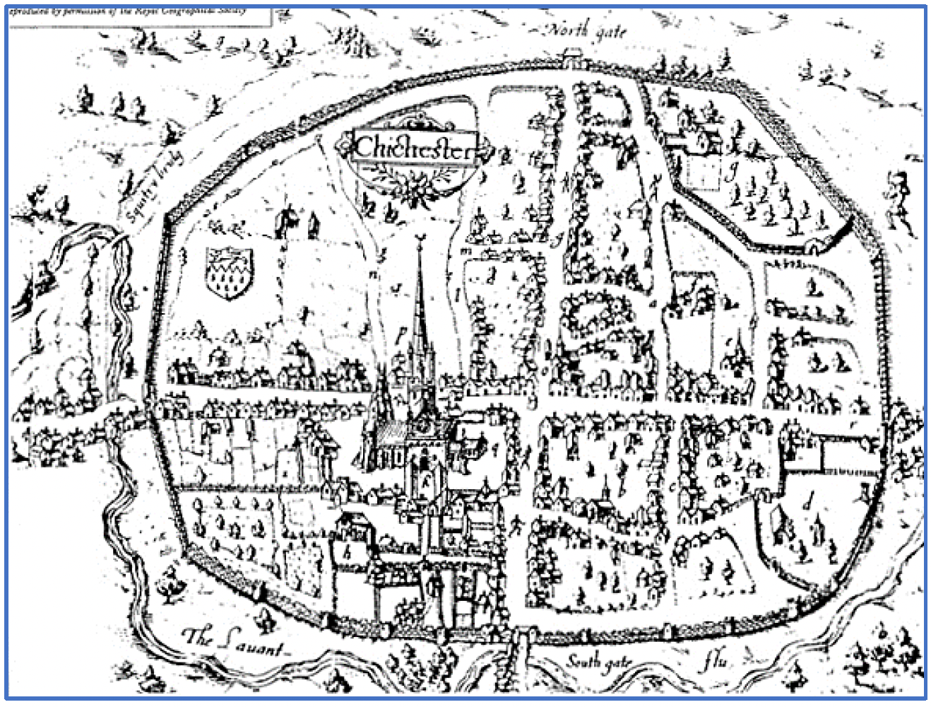
The Lavant River has been diverted, probably in the 9th Century, around the south side of the City, from its original course to the east of the city then on direct to the sea.
Westgate is already a significant suburb, with many houses each side of the road. The church of St Sepulchre is just at the west edge of the map.
1610 John Speed
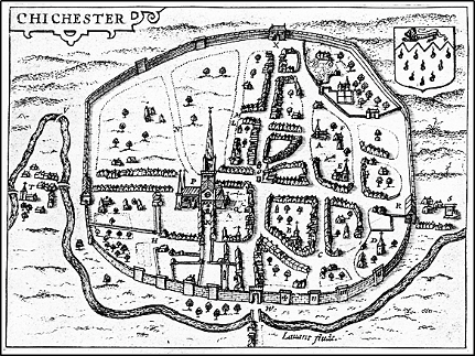
Very similar to the Norden map, the city is here laid out much as today, with the Roman roads and gates to the North, East, South and West. The Cathedral is clearly shown. The Pallants are in the South west, with the home of the Black Friars in the far corner and the remains of the old Norman Castle to the north east, now the home of the White Friars.
The crest of the city, granted by Royal Patent in 1570, is proudly affixed to the top right corner. This Coat of Arms is officially described as “argent gutte-de-sang, on a chief gules a lion passant guardant or” – that is: “silver with red (blood) drops, a straight line not indented, with leopard of England”.
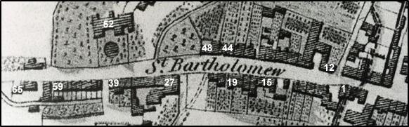
1769 Yeakel and John Gardener (WSRO ref: PM249)
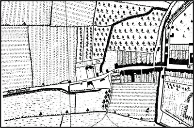
In this detail, Westgate is the road “from Portsmouth”, running across the middle of the map
Moving from west to east and starting on the right (East), the capital letter “W” is for West Street. The first turning right is North Walls with its first houses obstructing half the carriageway. This created the famous “bottleneck” including the exit line via the west gate which section is clearly visible. The next turning right is Scuttery (or Squittery) Lane, leading north to Scuttery Bridge, where you will see it crosses the Lavant River. This road is now called Orchard Street.
Westgate itself is densely lined with buildings as far as the “Burrying Ground” beside Church Lane (now Mount Lane), where the round church of St Sepulchre once stood. The next house to the left (west) is probably the old Vicarage for this Church.
St Sepulchre’s Church sat on the site of this graveyard and was destroyed in 1642, during the siege of Chichester in the English Civil War. The large clear plot around the vicarage became Charles Shippam’s land, where he would start his first shop in 1786.
There is then a pair of houses which still exist and the next clear plot is the Tannery, which had been started about 1550. By this point the river has crossed back under Westgate and the vicarage to the south of the road. Maltings had been founded in the Squittery Fields to the north side of the road, presumably opposite the vicarage, and the brewery was set up in the grounds of the big house built in 1751. Seen here to the west of the Lavant River which ran north-south through the property and an essential part early on in the making of the beer.
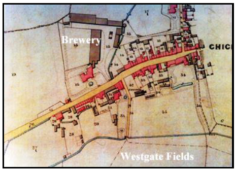
1812 Survey by John Loader (WSRO)
This map clearly shows the Brewery. The lower map is a portion of the larger map with some modern house numbers imposed so you can orientate yourselves.
Walking from West Street on the right, the first turning right is North Walls. The open space to the left (south) is the yard of the White Horse Inn, around which houses for the “poor” had been built. Then through the bottleneck and across the Lavant – now shown as a dotted line, since it had been enclosed in a culvert (and remains so to this day).
The courtyard on the left belongs to no. 3 and still exists behind the metal gates. On the opposite side to the courtyard no 12 was the Swan Inn, which must have been a much bigger establishment (it was rebuilt in 1936 and is now called the Crate and Apple.)
Further to the left (west) beyond no.19, the old graveyard is clearly shown with a path across it. This “burying ground” remained in use, even when there was no church standing on the site. The next entrance to the left is Church Lane, which ran south into the Westgate Fields.
Nos. 27 to 39 mark the Shippam business buildings, where no 27 was Charles Shippam’s house with his stables and slaughterhouse behind and his warehouse and shop (no. 39) with frontage onto the road.
Next and opposite, No. 52 is the house belonging to the Brewery owner. No. 59 is the last in the row of Tannery Cottages which backed onto the Lavant River. No. 65 was the Master Tanner’s residence.
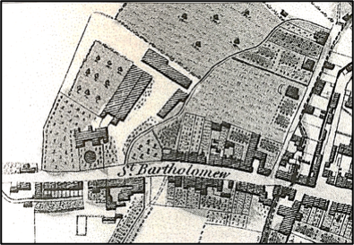
1836 Tithe map (WRSO)
This map shows more clearly the layout of the houses and gardens, many of which have remained largely unchanged in nearly 200 years.
The numbers are not the modern day house numbers, but refer to a key which gives the names of the owners or occupiers who paid that particular tithe:
- Tithes 14 and 15 belong to the Brewery
- 28 is the Tannery
- 31 is Shippam’s
- 33 is modern day house no 15
- Regarding 34 and 35, the very large garden belongs to what is now modern day no. 3
- 37 is the churchyard with the church (St Bartholomew’s) now finally rebuilt
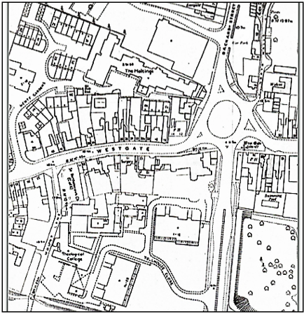
1912 Ordnance Survey Map
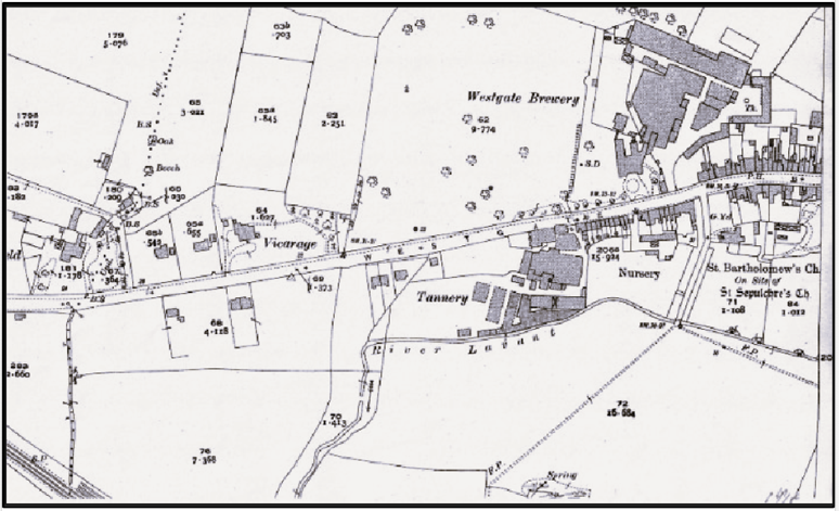
Westgate in the early C20
Read from right to left, the layout of both the Brewery and of the Tannery clearly dominate, giving Westgate still quite an industrial feel. The brewery complex sprawled as far East to where the PH is marked. This was the “Waggon and Lamb”, now a private residence at no. 34.
One can see that building work has now begun to spread west beyond the Tannery. The large vicarage on the north side was for St Bartholomew’s Church and is now a set of apartments at no.74. Throughout this period, Westgate continued growing to the West (left), with even a few houses appearing beyond the railway crossing. This is not visible here, but the railway can be seen cutting across the bottom left hand corner of the map.
1966 Ordnance Survey
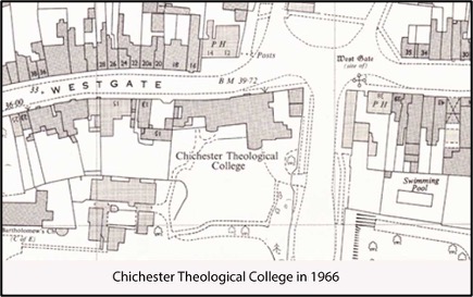
In the 1960s, four houses on the north side of Westgate were knocked down, to remove the “bottleneck” referred to above. The White Horse Inn to the south side was also demolished to make way for a new road. This ran up from the railway station to join Westgate just outside the position of the old West Gate, an essential link between the old Portsmouth Road and the railway station which had originally been planned back in 1888 to join these two places but via Mount Lane.
On this map, from right to left, notice:
- The PH (public house), now the Chichester Inn
- The road going north opposite the pub is a re-positioned North Walls
- The next entrance west is the junction with Orchard Street, but not yet with a roundabout
- The PH on the next corner is the Crate and Apple
- Opposite, the Theological College owned what are now numbers 1 the Courtyard (the old stable and coach house) to no.9 Westgate
- The house numbers shown are the modern post-1950 numbers
1979 Ordinance Survey (WSRO SU 8504 NE 1979)
By 1979, Westgate Fields Road had been made into a double carriageway as part of the Chichester Gyratory System, although Orchard Street has remained a single carriageway. The double carriage way was renamed “Avenue de Chartres.” A roundabout has been built at the junction.
The main building of the Theological College had moved to what is now Marriott House old people’s home, next to the church. The playing field which had formed part of the garden of no 3 sold, and Tollhouse Close apartments built. The College still owned the old Westgate building (until 1985) as accommodation for students.
The Brewery closed in the 1950s, burnt down in 1979, and Henty Gardens and The Maltings have now been built on the site.
2025 Developer’s Plan
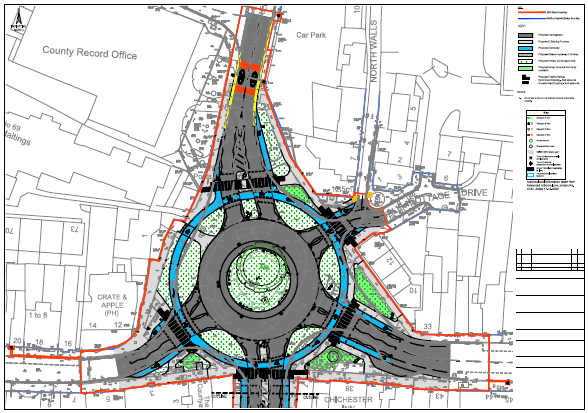
In 2025, as part of the investment in infrastructure by the developer of Minerva Heights, the Ave de Chartres roundabout was redesigned to a Dutch-style standard, with a priority lane for cyclists (in blue) and a zebra crossing on each arm.
Richard Brownfield and Colin Hicks 2025