Historic Maps of Westgate

Roman Roads (© David Stokes)

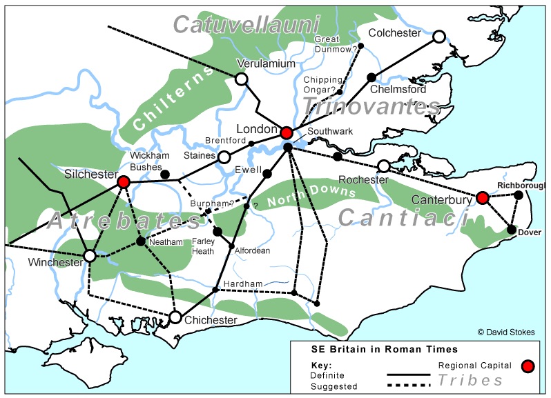
Westgate was not a metalled road in Roman times, although it was an important route to the palace at Fishbourne, onto Bitterne and then Winchester. Note the short road from Chichester to Dell Quay in the south, which came into use when Fishbourne Harbour silted up and the main port for goods and people was moved there.

History of 40 Westgate

Formerly number No 34 (1900-1950 numbering)

Known in recent memory as Deering’s sweet shop, this property has been a shop since before censuses began in 1841. At that point it was a bakery already being run by George Hackett, aged 35 and who describes himself as a baker, a recognised trade of trained artisans. He was still there in 1851 census – Hackett, George (55) now titled Master baker – and in 1861 – Hackett, George (66) Master baker. Still working at age 66!

St Bartholomew’s Church (updated)

THE ORIGINAL ST SEPULCHRE’S CHURCH 

Colin Hicks writes:

Originally on the site of the graveyard at St Bartholomew’s on the corner of Mount Lane and Westgate, stood a church that was probably built in the 12th century. This was round with a circular apse over the altar, a shape associated with the Knights Templar, so that the church became known as the Temple even though it was never associated with those militant monks. New Fishbourne church was probably a chapelry to St Bartholomew at this time. 

Henty Gardens & The Maltings

The Westgate suburb contains not just the main street but a collection of side streets that lead off the main road. This is part two of a series designed to present each of these in their own right. You can read about Mount Lane here. We do re-use material from elsewhere that risks being missed since it is scattered through other articles.

The Brewery

Henty Gardens occupies the eastern end of the Henty Brewery site on the north side of Westgate. This is where the original maltings were built in the 1780s, in the Squittery Fields, with the brewery itself more to the west.

Mount Lane

The Westgate suburb contains not just the main street but a collection of side streets that lead off the main road. This is part one of a series designed to present each of these in their own right. You can read about Henty Gardens and The Maltings here. It does re-use some material from earlier articles that risks being missed since it is scattered other postings.

The early history of Mount Lane is hard to identify. It is probable that there has always been a series of tracks leading from the Portsmouth Road into the Westgate Fields and of which the modern Mount Lane is a survivor. Perhaps because a church stood on the corner and the distant memory of a wayside Roman temple persisted.

The West End: who lived in your house?

Due to their fairly recent date, finding information about the properties in the 1930s development of Westgate, and the side streets, has proved a challenge except for the few that were built in earlier times. The censuses stop at 1921 for example and we have not trawled the electoral rolls for privacy.

However, we are endeavouring to write up as much of this recent history as is made available. This stops around 1950 to reduce or avoid invading the privacy of current residents.

The Theological College

Following extensive research by Dr Brownfield, here is a full description of the history of the Theological College, mostly taken from documents at the WSCC Record Office

The Story

The College was founded by William Otter in July 1838, the first such Diocesan College in England. The first Principal was Charles Marriott, of Oriel College, Oxford. He was a member of the Tractarian Society. The first donation for the college, of £50, was from W. E. Gladstone. 

The Westgate Brewery (updated)

The following entry is made up of a number of articles about the Brewery assembled from different sources by Richard Brownfield. [Square bracketed numbers and symbols] refer to the footnotes at the end of this post.

From time to time, we bring in a guest writer to add to the content of our website. We are grateful to local historian Alan H. J. Green for his permission to reprint from this article entitled “The Westgate Brewery”, which originally appeared in the Sussex Industrial Archaeology Society Newsletter 137 of January 2008 [*] 

The road we call Westgate (updated)

This is a comprehensive rewrite and expansion of my original 2017 post, recently undertaken by Dr Richard Brownfield. It pulls together a lot of different sources and is as full a historic description of the street as can be achieved. A major piece of research and a fascinating read.

Westgate is the road that left Chichester by the West Gate leading out of the Roman walls. The actual gate was demolished in 1773 but the south pillar is still standing, complete with a hinge (pintle), beside the Indian Restaurant. Westgate is also used to describe the ancient western suburb of St Bartholomew’s in Chichester, which grew up along the road that emerged beyond the West Gate.

error: Content is protected !!